The
National Climatic Data Center (NCDC) released its analysis of the past winter
today and the assessment for South Carolina? Near normal. The statewide average
turned out to be the 66th coldest and 65th wettest winter
on record. The ranking was based on 120
years of data.
An indepth look at weather and climate by South Carolina's Weatherman Jim Gandy.
Thursday, March 13, 2014
Sunday, March 2, 2014
Coming in the Back Door
This
winter has been a wild one for temperatures in South Carolina. There have been big swings from hot to cold
and back again. Now that meteorological
spring has begun (March 1st) the pattern continues.
A
dramatic change to our weather is about to take place. Cold arctic air is already in place across
much of the central U.S. Normally a cold
front moving in from the west would bring the cold air to our state. However, occasionally it comes in through the
“back door”.
High
pressure builds east and the cold air slides down the eastern seaboard faster
than it can come in from the west. It
becomes trapped between the ocean to the east and the Appalachians to the west. The cold front that surges south is known as
a “back door” cold front.
Typically
a wedge of cold air stays in place until something comes along to move the cold
air out, which is a very difficult thing to do.
The result can be days of overcast skies and chilly northeast winds.
This
time the back door cold front will be accompanied by a dramatic temperature
drop. When the front passes the
temperatures will likely drop 20-25° F in an hour or two. The front will be preceded by a band of rain
which will begin the temperature drop.
Winds will shift from a westerly direction to a northerly direction as
the front passes. The winds will
increase and there will be a wind chill to worry about in the late afternoon.
![]() |
| The RPM model forecast for 1:30 p.m. EST on Monday, March 3, 2014. This is from the 21z run of the model using the 12 km grid. Click on the image for a larger version. Image Credit: WLTX-TV\WSI. |
Wednesday, February 26, 2014
For Entertainment Purposes Only
For
almost a week there has been a persistent rumor that another snowstorm is on
the way. I traced this back to radio
spreading the rumor that Farmers’ Almanac had predicted the past two snowstorms
and was predicting a third. I was
frequently asked if there was another snowstorm on the way, for which I
answered no. The response was almost
always “Well, Farmers’ Almanac is predicting another snowstorm and it predicted
the last two.” What?
So
I investigated this claim. First let me
point out that there is a Farmers’ Almanac (dating back to 1818) and an Old
Farmer’s Almanac (dating back to 1792).
It was Old Farmer’s Almanac that was predicting snow. Second the forecasts are so vague as to be of
little value. Neither ever forecasted
sleet or freezing rain and thus the ice that was so devastating.
Yet
there were a few that were adamant that Old Farmer’s Almanac got it right. If that is the case, then why ever watch the
media. Let’s explore the claim.
I
do not have the forecast breakdown for January, but I did get it for
February. For the period of February
7-14, the forecast is for “periods rain and snow, then sunny, cold”. It was during this period that the snowstorm
occurred (11-13). But, wait! The forecast is for the entire region from
south Georgia to southeast Virginia. It
also includes the Piedmont as well as coastal areas.
Does
this forecast apply equally to all locations?
Are we to apply this with rain in the south and snow in the north? If so, where is the rain/snow line? Where is there any mention of ice? Where does it even say snowstorm? Merriam-Webster Dictionary defines snowstorm
as a disturbance of the atmosphere marked by a heavy amount of precipitation in
the form of small white ice crystals. In
their forecast how much snow will fall?
Saturday, February 22, 2014
Remembering #WinterMess 2
Little
did we know that the winter storm at the end of January would be the prelude to
a bigger storm two weeks later (February 11-13). A complex storm system came through South
Carolina in two waves. The first
occurred on Tuesday with snow over the northern Midlands and rain/sleet
elsewhere. This was followed by the main
batch of precipitation on Wednesday ending Thursday morning.
Most
of the snow occurred over the northern half of the Midlands. It was mainly sleet with some snow in
Columbia, but the precipitation became more snow farther north. The northern most counties of the Midlands
saw a considerable snowfall.
| Total snowfall as of 7 a.m. Thursday, February 13, 2014. This is based on observations from the National Weather Service Forecast Office in Columbia, SC. Image Credit: WLTX-TV. |
South
of Columbia it will a sleet/freezing rain mix.
The farther south you went the more freezing rain occurred. The southern Midlands saw the greatest
accumulation of ice as shown on the map below.
| Total ice accumulation as of 7 a.m. Thursday, February 13, 2014. This is based on observations from the National Weather Service Forecast Office in Columbia, SC. Image Credit: WLTX-TV. |
The
Midlands ended up on the dividing line between snow and ice. The northern half saw a snowstorm while for
the southern half saw an ice storm. Travel
became difficult if not impossible through some sections. The worst of the storm occurred over the
southern Midlands with the accumulation of ice.
An estimated 350,000 people lost power at the end of the storm. Some were without power for over a week. Schools remained closed for Wednesday through
Friday with some of the northern counties closing schools on Tuesday.
Tuesday, February 18, 2014
The #BigMelt
There
is finally some relief after a week of snow and ice followed by an
earthquake. It was quite cold this past
week following the 12th coldest January on record for Columbia. It was the 11th coldest for South
Carolina as a whole in January. The
weather warmed after the first winter storm at the end of January. Little did we know that it was a warm-up act
for the next winter storm.
Most
of the snow and ice melted as the sun returned on Friday and a warming trend
began. A cold shot of air on Saturday
only slowed the melt, but the warming trend continued on Sunday. This week will be noticeably warmer this
week. In fact, temperatures will be in
the mid to upper 70s by Thursday.
| The 7-day forecast for Columbia, SC, for February 18-24, 2014. Click on the image for a larger view. Image Credit: WLTX-TV. |
Monday, February 10, 2014
#WinterMess the Sequel
And
this time she means business!
The
big picture described in yesterday’s blog post is still on track, but the
details are a little different. This is
based on the latest computer model runs.
Basically, an upper-level system now in the southwestern part of the
country will combine with a disturbance moving in from western Canada and will
intensify over the Southeast. This will
induce a surface low to form first in the Gulf of Mexico and then off the
Southeast coast. High pressure over New
England will push cold air into the Carolinas setting the stage for winter
precipitation. It will be a “big ol’
mess” when all comes together.
A
Winter Weather Advisory has been issued for the northern midland counties of
Saluda, Newberry, Fairfield, and Kershaw.
This will be for an accumulation of snow and sleet mainly Tuesday
morning. The following is an update from
the previous post.
As
mentioned yesterday the forecast is a difficult one based on the timing and
various forms of winter precipitation that will occur. The Midlands will see it all; rain, freezing
rain, sleet, and snow. It appears that
the onset of precipitation will be late tonight as rain moves into the
area. The rain will likely change to
snow during the early morning hours for the northern part of the Midlands (Saluda,
Newberry, Fairfield, and Kershaw counties).
There could be enough accumulation to cause travel problems, so travel
through the northern Midlands needs to be monitored. The snow will change to rain and taper off
during the afternoon. This will be the
first surge of moisture into the region.
Sunday, February 9, 2014
Another #WinterMess?
Just
two weeks ago a winter storm moved through the region producing a combination
of rain, freezing rain, sleet, and snow.
Many thought this was it for the winter, but Mother Nature had other
ideas. Look here for a rundown of
WinterMess #1.
Incredulously
another winter storm is headed through the Southeast. This time it will be a little different from
the previous storm (i.e., no two storms are identical). A complex weather pattern will develop over
the Southeast with an upper-level disturbance moving east and helping to
develop a low pressure system off the Carolina coast. A surge of cold air will be pushing into the
Carolinas ahead of this which will turn the rain into a wintry mix.
The
models are a little better in converging on a solution. There is still considerable uncertainty due
to the tight area that the worst will fall.
A difference of just 20 miles can make a huge difference in the forecast
even at this time range (less than 48 hours).
This
blog post is designed to give you a heads up on our thinking and the time frame
that things will occur. There is only
moderate confidence in the details, but the overall picture has good
confidence. The scenario and forecast
that follows was derived from the 09z, 12z, 15z, and 18z runs of the WSI RPM
model along with the 12z runs of the WRF, GFS, ECMWF, and GEM models on Sunday,
February 9, 2014. Each model is slightly
different, but the details were mainly from the RPM model. This represents my best guess at this point.
Friday, January 31, 2014
A Look Back at the #WinterMess
The
snow that everyone graved finally came to the Midlands. The same storm system that affected
Birmingham and Atlanta also affected Columbia, SC. Rain and sleet began to fall before noon on
Tuesday, but it wasn’t enough to measure and didn’t cause any problems. The lower atmosphere was quite dry so that it
would take hours of light precipitation to moisten the atmosphere enough to
allow for any significant precipitation.
Finally
a band of rain/freezing rain moved across the southern half of the Midlands
just before dark. This was followed by
snow in the northern part of the Midlands.
It eventually reached Columbia in the form of freezing rain. At WLTX we pick up an ice accumulation of
1/10 of an inch before the precipitation changed over to snow. The southern third of the Midlands saw ice
accumulations of a ¼ to ½ inch.
The
air was chilled by the rain/sleet/snow mix and temperatures fell below freezing
over all of the Midlands shortly after sunset.
The precipitation changed to snow which fell mainly from 7:30 p.m. to
about 2 a.m. across the Midlands. Snow
ended from west to east and the amounts didn’t vary a great deal across the
Midlands.
Amounts
were generally 2 to 3 inches across much of the area. It was a wet snow which made for great
snowmen and snowball fights. Here is a
view of the region from the satellite the next day:
Tuesday, January 28, 2014
A Major #WinterMess
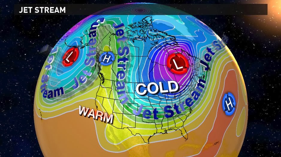
First,
the jet stream in the upper atmosphere is diving far to the south from the
Arctic region. The term polar vortex was
used earlier in January to describe to cold weather seen at that time. Well, it’s baaaaack! This time a piece of the polar vortex is
centered just east of James Bay in Canada.
Cold Arctic air is plunging south to the Gulf coast and covering much of
the Southeast.
| The 500 mb pattern for 00z Tuesday, January 28, 2014. Click on the image for a larger view. Image Credit: WLTX-TV. |
All
of the computer models have been signaling this for the past few days. However, their solutions have differed as to
how and when the precipitation will develop across the Southeast. Some of the models have brought the cold air
in too fast resulting in primarily a snow forecast. Others have slowed the advance of the cold
air which has produced forecasts of freezing rain, sleet, and snow.
Sunday, January 26, 2014
A #wintermess for Tuesday, January 28, 2014
The
National Weather Service issued a Winter Storm Watch for the midlands of South
Carolina Sunday afternoon. It is for the
time period from Tuesday morning to Wednesday afternoon. Immediately everyone was jumping up and down
for joy over the prospect for snow. Not
so fast bucko! Everything is not as it
seems.
It
took quite a bit of careful analysis to decipher what the scenario would
be. The computer models have been all
over the place with this system; from no snow to more than 15” of snow. Even our own in-house model has seen big
run-to-run swings with 2 to 4 inches of snow in one run to no snow the
next. So what to do?
I
have decided that the American model (GFS) seems to be preforming the best for
now. The NAM model has been showing wild
swings run-to-run and the European model (ECMWF) seems too cold. None of the models are perfect, but the GFS
seems to be closest to actual observations in the forecast.
Thus,
here is the forecast for Columbia, South Carolina over the next seven
days. This was posted Sunday, January
26, 2014:
![]() |
| The seven-day forecast posted Sunday, January 26, 2014 for Columbia, SC. Click on the image for a larger view. Image Credit: WLTX-TV. |
Subscribe to:
Posts (Atom)