Today marks the mid-point of meteorological winter (December 1 - February 29). The average temperature for the period December 1 - January 15 this winter has been 50.5 degrees F making it the 16th warmest in 124 years of records. Contrast this to last year when it was the 3rd coldest on record for the same time period. Furthermore, the previous winter (2009-2010) saw the 7th coldest on record for this time period. What a turn-around!
We have not been alone. Much of the U.S. has been experiencing much above normal temperatures. Below is a look at the mean temperatures for December and the first two weeks of January:
 |
| Mean Temperature for the 30 days ending on Dec. 31, 2011. Image Credit: NOAA/CPC. |
 |
| Mean Temperature for the period Jan. 1-13, 2012. Image Credit: NOAA/CPC. |
We continue to have a seesaw pattern across much of the U.S. Some of the northern states are seeing the first significant snowfall since the October storm. Cold air covers much of the eastern U.S.
However, a warm-up in on the way. The warmer air will be surging north in advance of a cold front that will pass through South Carolina Wednesday morning. Temperatures will climb into the low to mid 60s on Tuesday. This will be followed by a brief cool down. Temperatures will drop into the mid to upper 20s by Thursday morning.
It appears that a more dramatic warm-up is in store for the last week in January. All of the computer models are forecasting a warming trend for next weekend into the last week of January. In fact, temperatures may climb into the mid 70s in the time period of Monday, January 23, to Wednesday, January 25. The recent 8 to 14 day forecast illustrates this:
 |
| The 8-14 day forecast of temperature from Sunday, January 22 to Saturday, January 28, 2012. Image Credit: NOAA/CPC. |
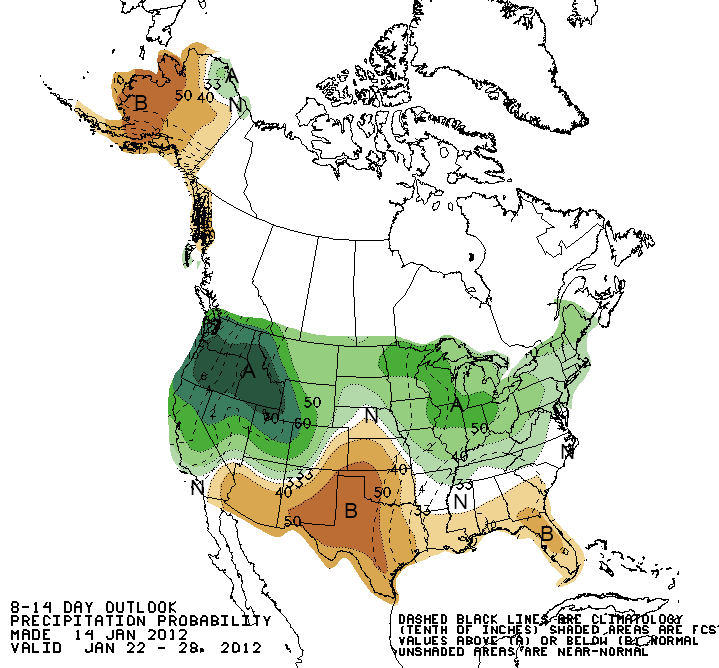 |
| The 8-14 day forecast of precipitation from Sunday, January 22 to Saturday, January 28, 2012. Image Credit: NOAA/CPC. |
This forecast has a very good chance of verifying given the current weather patterns. Some private meteorologists have been forecasting harsher conditions because the Arctic Oscillation is shifting from the very positive phase to neutral of slightly negative. However, La Nina is still in progress and the typical pattern for the South is warmer than normal and drier than normal for this pattern.
Therefore, the midlands of South Carolina is likely to see warmer and drier than normal conditions for much of January. Keep in mind that December was the 14th warmest on record and about 2 inches below normal for rainfall. This does not bode well for the spring planting season.