Update: 1:35 a.m. EDT August 29,
The eye seems to have stalled off the coast of Grande Isle, LA. It seems to be doing a loop on radar and this will delay landfall. Much of southeastern Louisiana will be pounded by high winds, heavy rains, and storm surge for much of Wednesday.
---------------------------------------------------------------------------------------------------------
As Isaac makes landfall in southeastern Louisiana it is likely to be a category 1 hurricane. This may not sound like much, but the winds are still a danger and shelter will be needed. However, it is the water, both surge and rain, that are the biggest threat. The storm is expected to slow down as it moves through southeastern Louisiana and could produce rain through Wednesday night.
The eye seems to have stalled off the coast of Grande Isle, LA. It seems to be doing a loop on radar and this will delay landfall. Much of southeastern Louisiana will be pounded by high winds, heavy rains, and storm surge for much of Wednesday.
 |
| The radar view from Slidell, LA at 1:05 a.m. EDT, August 29, 2012. |
---------------------------------------------------------------------------------------------------------
As Isaac makes landfall in southeastern Louisiana it is likely to be a category 1 hurricane. This may not sound like much, but the winds are still a danger and shelter will be needed. However, it is the water, both surge and rain, that are the biggest threat. The storm is expected to slow down as it moves through southeastern Louisiana and could produce rain through Wednesday night.
 |
| The forecast for Isaac as of 11 a.m. EDT, August 28, 2012. Click on the images for a larger view. Image Credit: NOAA/NHC. |
At
11 a.m., Tuesday, Isaac was still a tropical storm; however it was close to
becoming a hurricane with maximum sustained winds of 70 mph. This is strong enough to take out trees and
power lines with some minor structural damage to buildings. The satellite picture below showed the storm
getting better organized, but the bulk of the rain was east and south of the
center.
 |
| Visible satellite picture of Isaac at 10:45 a.m., August 28, 2012. Image Credit: NESDIS. |
The
storm surge will be the first big threat.
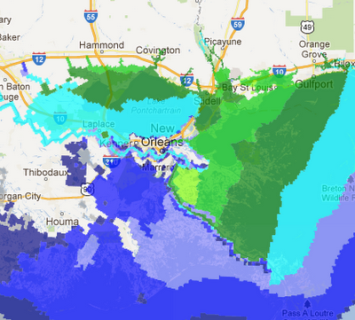
The map below shows the storm surge expected as the storm makes
landfall. There will be considerable
flooding of low-lying areas; however New Orleans is protected by the levees and
should be fine. Many of the coastal
areas will be flooded.
 |
| Forecast of the storm surge as Isaac makes landfall issued at 8 a.m. EDT, August 28, 2012. Image Credit: NOAA/NHC. |
Isaac
will slowly weaken as it moves inland.
This weakening process will unleash a torrent of rainfall particularly
east of the center. The heavy rainfall
now east and south of the center will likely rotate to be northeast of the
center once on land. From that point on
this will be the place to watch for flash floods. Rainfall is likely to be heavy from the
central Gulf coast into the Midwest over the next five days.
 |
| Projected 5-day rainfall issued at 8 a.m. EDT, August 28, 2012. Image Credit: NOAA/NHC. |
The
large circulation around the storm will continue to bring tropical moisture
north into the Southeast. This is the
reason for the rains from Florida into the Carolinas. An additional two inches of rain this week in
Columbia, SC, will make the 20th wettest August on record the third
wettest on record in what has already been a very wet month.
Those
of you planning on going to the USC vs Vanderbilt game Thursday night, take the
rain gear. There will be a chance for
showers, but the heavier rains will be well southwest of Nashville. The rain should not interfere with the game.
