Update: 10 p.m. EDT
Sandy made landfall about 5 miles southwest of Atlantic City, New Jersey around 8 p.m. EDT. It came ashore as an extratropical cyclone as Sandy made a quick transition during the late afternoon. The storm still had sustained winds up to 80 mph and was moving west-northwest at 21 mph. Sandy slowed as it moved inland and may slow some more over the next few hours.
 |
| The windfield around Sandy as of 9 p.m. EDT, October 29, 2012. Click on the image for a larger view. Image Credit: NOAA. |
Notice the area colored in yellow. These are winds in the range of 45 to 60 mph. This is a very large area of high winds and it is pushing water into New York harbor due to the southeast winds. It produced a record flood for lower Manhattan.
Sandy continues to move inland and was near Wilmington, Delaware as of 10 p.m. EDT. Inland winds of 40 to 50 mph were common. This heaviest rains were now south and west of the center.
 |
| The radar from Dover AFB as of 10 p.m. EDT, October 29, 2012. Sandy was centered southwest of Wilmington, Delaware. Image Credit: WLTX-TV. |
Heavy snows are now falling in West Virginia and western Virginia. The snow extends south into the mountains of North Carolina, but amounts have been generally light so far. More snow is expected overnight and through the day on Tuesday.
Update: 6 p.m. EDT
Sandy is now extratropical. However, that does not alter the overall pattern of the storm. It has been making rapid transition during the past few hours. The 5 p.m. analysis of the wind field is below with the radar composite from 5:48 p.m. The storm is approaching Cape May, New Jersey and should make landfall in about an hour.
 |
| The wind field over the radar. Click on the image for a larger view. The storm is extratropical. Image Credit: NOAA. |
Update: 2 p.m. EDT
Hurricane Sandy is accelerating and turning to the west-northwest. The storm has been moving northwest over the past three hours, but it is clearly turning. Forward motion is now 28 mph and central pressure is 940 mb (27.76 in.). Maximum sustained winds still at 90 mph, but it appears that an area of strongest winds are developing north of the center.
 |
Windfall analysis as of 1 p.m. EDT October 29, 2012. Image Credit: NOAA.
|
 |
| Radar image of Sandy as of 2 p.m. EDT October 29, 2012. Image Credit: WLTX-TV. |
The faster forward motion means that the center will cross the coast earlier than forecast. In addition, it could move faster as it is affected by a strongly negatively tilted trough shown in this mornings upper-air analysis. The jet stream may cause a further deepening of the pressure.
 |
| Analysis of the 250 mb level showing strong winds along the East Coast. Image Credit: NCAR/RAP. |
Dateline: Noon
Hurricane
Sandy is now the strongest hurricane observed north of North Carolina. At 11 a.m. EDT the National Hurricane Center
(NHC) reported a minimum central pressure of 943 mb (27.85 in.) with maximum
sustained winds of 90 mph. The hurricane
had turned and was moving north-northwest at 18 mph. It is expected to gradually turn to the
northwest this afternoon and west-northwest by landfall. Landfall is expected this evening (near 9
p.m. EDT) near Cape May, New Jersey.
 |
| Satellite view of Sandy as of 10:15 a.m. October 29, 2012. Image Credit: NOAA. |
 |
| The forecast for Sandy for 8 p.m. EDT October 29, 2012. The map shows the pressure field (in millibars), winds (in knots), and precipitation. This model has Sandy making landfall at this time. Click on the images for larger views. Image Credit: WSI. |
The
hurricane has been moving over the Gulf stream this morning giving rise to
thunderstorms around the center forming an eye at times. It will move into colder waters in the next
couple of hours so further strengthening is not likely. However, the wind field is already huge and
not likely to grow further. Tropical
storm force winds extend 940 miles across the storm along the southwest to
northeast axis. They extend 700 miles in
the southeast to northwest axis.
 |
| Satellite and Radar composite as of 11 a.m. EDT October 29, 2012. Click on the image for a larger view. Image Credit: NOAA. |
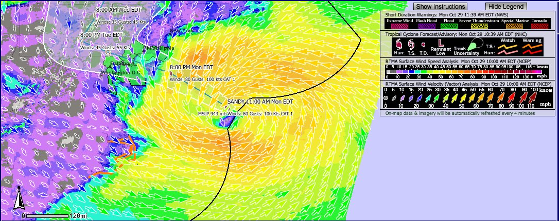
 |
| The wind field as of 11:30 a.m. EDT October 29, 2012. Click on the image for a larger view. Image Credit: NOAA. |
Sandy
is a powerful storm and the pressure is what you would expect with a category 4
hurricane. However, Sandy is not a pure
tropical system. It is a hybrid and is
on its way to full extratropical storm status in 12 hours. The large wind field is more typical of
wintertime storm systems. In fact, the
strongest winds are about 100 to 150 miles southwest of the center.
From hurricane to
blizzard
Cold
air covers the land areas and as moisture is pushed into the Appalachians it is
changing to snow. Snow is already
falling from the Smokies to West Virginia.
Blizzard Warnings are in effect for the mountains of West Virginia where
up to 4 feet of snow could accumulate.
Snow is accumulating in the mountains of North Carolina. There was already 4 inches on the ground at
Newfound Gap near daybreak. An
accumulation of 1 to 2 feet is expected with isolated amounts to 3 feet in the
Smokies.
 |
| Snowfall forecast for the Appalachians using the 12z RPM model October 29, 2012. Click on the image for a larger view. Image Credit: WSI. |
Travel
through the mountains is discouraged at this time. If you must travel, please dress warm and take
your cell phone.
I
will be updating this blog post throughout the day. Stay tuned!