Tropical Storm Karen formed just north of the Yucatan Peninsula Friday morning (correction: that should be Thursday morning). The system had been moving northwest through the western Caribbean since early in the week. Conditions were finally favorable for development.
Now
Karen takes aim on the U.S. It has been
moving slowly through the southern Gulf of Mexico and toward the north-northwest. Hurricane hunters found winds of near 60 mph
this morning prompting the upgrade to tropical storm status.
As
of 11 p.m. EDT, Thursday, Tropical Storm Karen was 340 miles south of the mouth
of the Mississippi River moving north-northwest at 10 mph. Maximum sustained winds were 65 mph in
squalls to the northeast.

The
satellite picture for late this afternoon showed an asymmetric pattern to the
storm from a southwestern wind shear. This
was keeping the system from intensifying quickly as most of the thunderstorm
tops were displaced east of the center.
It is possible that Karen could increase to hurricane strength before
landfall, however shear is expected to increase as it approaches land. This may weaken the storm before reaching the
coast.
 |
| The satellite image of TS Karen as of 11 p.m., October 3, 2013. The track models are plotted from the 00z data. Click on the image for a larger view. Image Credit: WLTX-TV. |
Mid-level
shear is not much at this time, but that will change in a few days. A vigorous trough has moved into the western
U.S. This is already creating an early
fall storm with heavy snow expected in western South Dakota. Much colder air is spreading through the
northern Rockies. The trough is digging
into the West sharpening the ridge over the Southeast. Southwest winds will increase the shear and
steer the storm as it make landfall.
 |
| The 500 mb pattern for 12z October 3, 2013. Note the trough digging into the western U.S. Click on the image for a larger view. Image Credit: WLTX-TV. |
The
forecast is in line with the track models.
Karen should move northward to the central Gulf coast and then turn
northeast. The steering currents will
probably accelerate the forward motion as it makes landfall. There is
a wide range of solutions as to the forward speed. This will make a big difference in the timing
of the storm and the duration. It will
also affect how much rain falls.
 |
| The National Hurricane Center forecast as of the 11 p.m. EDT advisory on October 3, 2013. Click on the image for a larger view. Image Credit: WLTX-TV. |
South Carolina
The
weather will be very warm and increasingly humid on Saturday. No rain is expected so it should not
interfere with the Kentucky/USC football game Saturday evening. Clouds will be moving into the midlands of
South Carolina by Sunday morning. There
will be an increasing chance for showers and thunderstorms during the afternoon. Most of the rain will come Sunday night into
Monday morning. The beginning and end of
the rain will be determined by the storm’s speed.
Rainfall
it not expected to be particularly heavy, but the computer models at the range
of 4 days indicate it should be in the range of 0.5 – 1.0 inches. As usual with tropical systems there could be
isolated amounts to 2 inches.
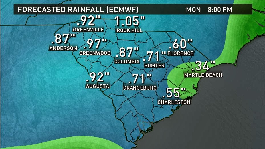 |
| Rainfall forecast as of 8 p.m. EDT, Monday, October 7, 2013, from the European model. Click on the image for a larger view. Image Credit: WLTX-TV. |
 |
| Rainfall forecast as of 8 p.m. EDT, Monday, October 7, 2013, from the U.S. model. Click on the image for a larger view. Image Credit: WLTX-TV. |
Karen
will likely be a tropical depression as it moves through South Carolina and it
could be losing tropical characteristics.
The path of the storm may increase the possibility of isolated
tornadoes, but that will be closer to the coast if the center moves through the
Midlands. Winds gusts to 25 or 30 mph
may be possible, but the winds should be less than 20 mph most of the time.
Be
sure to watch of updates on my Twitter account: @JimGandyWLTX and on the
station Facebook account: WLTX News19.