Droughts can be insidious. Just when you think they’re gone, they’re
back. Actually it never went away in the
Southeast, it just moved around. The
center of the drought began in northeast Florida in 2011 and moved to southern
Georgia a year later. Now the center of
the drought is central Georgia and it is beginning to expand thanks to a dry
January.

| The Drought Monitor for the end of January 2011-13. Click on the image for a larger view. Image Credit: USDA. |
The current drought began in the Southeast with the end
of El Nino in 2010. That was followed by
two years of La Nina which brought drier than normal conditions particularly in
the winter and spring. The worst of the
drought has been centered in central Georgia where extreme to exceptional
drought conditions have persisted for two years.
However, drought conditions for southeast Georgia and
northeast Florida actually disappeared this past summer thanks to two tropical
weather systems (Beryl & Debby) which inundated the region with rain in
late May and June. Drought is creeping
back into those areas.
The picture of drought hasn’t change much year-over-year
in South Carolina when you look at instantaneous pictures for the end of
January. However, that does not do
justice to the drought situation.

 |
| The Drought Monitor for South Carolina. The top image compares January 2012 & 2013. The bottom image compares the end of the water year in 2012 with the end of January 2013. Click on either image for a larger view. Image Credit: USDA. |
Last winter and spring were quite warm and dry. The drought worsened into May. However, rain began to increase during the
month which lasted into the typical summer rainy season. It was topped off by a surplus of about 4.5
inches in August. Thus, by the end of
the water season (late September), much of the state was out of drought. The drought has intensified since that time
as this winter has been quite dry.
There has been less than an inch and a half of rainfall
since the beginning of the year (January 1 – February 5) bringing the deficit
to about three inches.
The drought situation has worsened over all of the state with the
exception of the mountains.
Prospects for rain are good in both the short-range and
medium-range forecasts. First, there is
a very good chance for a system moving along the Gulf region to move rain into
the Midlands on Thursday. The map below
is a first look at rainfall from our RPM model.
Amounts of .5 to 1 inch are forecast by the model which is in the
mid-range of computer models from the National Weather Service. Future runs of the computer models will vary
depending on how much moisture is drawn into the system.
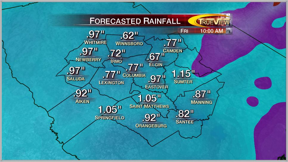 |
| RPM forecast for rainfall ending 10 a.m. EST on Friday, February 8, 2013, based on data from the 4 p.m. run on February 5th. Click on the image for a larger view. Image Credit: WLTX-TV. |
Then there will be a pattern change for much of the
eastern half of the country going into next week. Temperatures will be warmer than normal and
rainfall will be greater than normal. It
is hard to know how much rain may fall early next week, but the pattern
suggests that it could be in the one to two inch range. There is still considerable uncertainty in
that part of the forecast, but it certainly looks like beneficial rains are on
the way. This might be the best rainfall
seen since August.

 |
| The 6 to 10 day outlook for the period February 11-15, 2013. The top image is for temperature and the bottom image is for precipitation. The percentages are for above and below normal values. Click on the image for a larger view. Image Credit: NOAA/CPC. |
This would be a start to easing the drought, but there is
much work to be done by Mother Nature.
The outlook for the spring is for drier than normal conditions. If this is the case, then the drought will
likely get worse before reaching the summer rains.