Drought
has been the rule since the fall of 2009 in parts of South Carolina. Only 6 out of the next 36 months saw above
normal rainfall in Columbia, South Carolina until 2013. Then the pattern changed and 2013 has been
wetter than normal. In fact, 4 out of
the last 6 months have been above normal and July is likely to add to that
total.
The
first week of July has been extremely wet. The airport has seen 2.19 inches of
rain while the city has received 4.35 inches of rain in just six days. July is normally the wettest month of the
year, but this year has been wetter than normal. In fact, the last two weeks have been quite
wet.
The
map below shows the observed rainfall across South Carolina for the past two
weeks ending on July 6. Note that the
area east of a line from Lancaster to Columbia to Barnwell has seen the
greatest rain with 10 to 15 inches of rain in eastern Orangeburg and
southeastern Clarendon counties. The
rain has been less west of the line until you get into the upstate of South
Carolina.
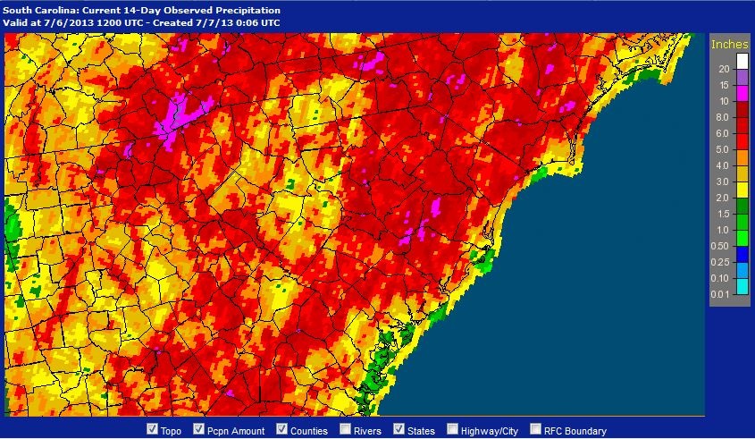 |
| The 14-day observed rainfall ending at 8 a.m. July 6, 2013. Click on image for a larger view. Image Credit: NOAA/AHPS. |
Heavy
rainfall has resulted in significant rises in many of the rivers with minor
flooding of the Congaree River in the Columbia area. The Congaree Swamp has seen considerable
flooding over the past month closing some of the trails. This is likely to continue as much of the
flood waters from the Upstate have yet to pass through the Midlands.
So,
why is this happening? It turns out that
our weather is linked to a pattern which has caused record heat in the
Southwest and cooler than normal conditions in the Midwest.
The
spring weather pattern was one of a persistent trough of low pressure over the
eastern U.S. and a ridge of high pressure over the western U.S. in the upper
atmosphere. The unusually cool spring
and northwesterly flow over the central U.S. contributed to a late tornado
season. This pattern began to change in
mid-May and tornado activity surged toward the end of the spring season.
Normally
the jet stream, a river of higher velocity winds in the upper atmosphere,
retreats to the north. This year it
retreated north of the U.S./Canadian border as expected, but it left a
ridge-trough-ridge pattern in its wake and persisted for much of late June into
early July.
 |
| The upper atmospheric pattern for 00z July 4, 2013. The dashed black lines are the axis of the troughs. Click on image for a larger view. Image Credit: WLTX-TV. |
The
high pressure system aloft in the West contributed to a brutal heat wave in the
Southwest. Death Valley, CA, reported
the highest temperature ever recorded in the U.S. for the month of June when it
reached 129 degrees F on the 30th.
This tied the record with 129 observed at Volcano, CA, a former town
near the Salton Sea, on June 23, 1902.
Las Vegas reached 117 degrees F at McCarran International Airport to tie
the all-time record high temperature.
Meanwhile
the trough in the central U.S. brought relief to two years of scorching heat to
the Plains. Temperatures were as much as
30 degrees cooler than readings a year earlier in parts of the Midwest. Recent rains had relieved much of the drought
in that area.
East
of the trough a persistent southerly flow brought abundant moisture to the East
coast. This has been the pattern for
much of the last two weeks.
 |
| The surface map for the evening of July 3, 2013. Note the extensive cloud cover for the eastern third of the U.S. The arrow indicate the prevailing wind at the surface. Click on image for a larger view. Image Credit: WLTX-TV. |
The
trough has combined with the flow around the Bermuda high to bring copious
amounts of moisture to the Southeast.
The result has been heavy rainfall with flooding from Alabama to the
East coast.
The
Bermuda high has moved slightly west over the past few days. By moving westward the axis of heavy rain has
been from the Florida Panhandle through Alabama and Georgia northward. Some areas of southwestern North Carolina
have seen 15 to 20 inches of rain in the past two weeks.
This
shift will allow more sunshine to return to the midlands of South
Carolina. There will still be a chance
for rain, but now it will be hotter.
High temperatures will be in the low 90s which is normal for this time
of year. However, the abundant rainfall
will result in high humidity. This will
produce heat indices above 100 degrees F even with highs in the low 90s. Thus, the pattern will shift from wet to
steamy. Drink plenty of water.
Side
Note: The past month has been a busy one for me and there have not been any
posts to the blog. I have been on
vacation and at the AMS Broadcast Conference.
If you follow me on Twitter (@JimGandyWLTX), you already know this. I was fortunate to be in a climate change
short course before the conference which had presentations from some of the
leading climate scientists. There were
some fascinating discussions which I will share in the coming months.
Needless-to-say,
there is a great deal of research in progress on the earth’s climate. New research is bringing to light why the
recent pattern we have experienced may not be so unusual.
Further
reading:
Jeff
Master’s blog post on the jet stream
Climate,
Ice, and Weather Whiplash