A
weather pattern we have seen many times since late October, 2013, has
reappeared in its amplified form. The
ridge of high pressure in the upper atmosphere has been building since late
last week along the Pacific Coast, stretching from northwest Mexico to
Alaska. This has pushed the jet stream
far to the north into Alaska and the Yukon.
 |
| The 500 mb pattern for North American at 00z January 21, 2014. Click on the image for a larger view. Image Credit: WLTX-TV. |
The
result has been unseasonably warm temperatures for this time of year. It is still cold, but in Fairbanks the
temperature averaged 24° F above normal on Monday. There have been wild swings in Fairbanks, AK,
this month with its coldest temperature of -41° F on January 12th
& 13th, and its warmest temperature at 34° F on January 17th. On that day the temperature averaged 32° F
above normal.
 |
| Alaskan temperatures at midnight January 21, 2014. These are warm readings for central Alaska in January. Click on the image for a larger view. Image Credit: WLTX-TV. |
As
the jet stream plunges south into the southeastern U. S. it has been bringing
to cold Arctic air from north central Canada.
Here temperatures have been -20° F to -40° F. This is not as cold as the air mass at the
beginning of the month, but still cold enough to cause problems.
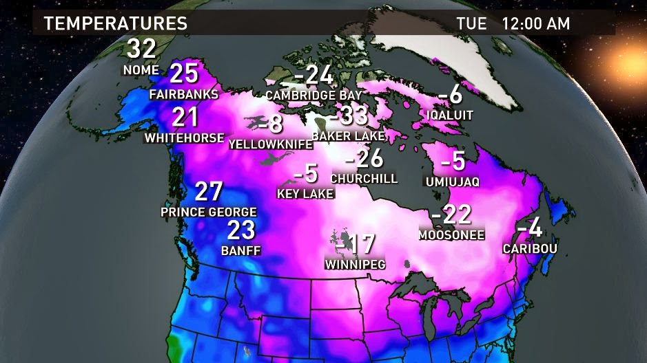 |
| Canadian temperatures at midnight January 21, 2014. Click on the image for a larger view. Image Credit: WLTX-TV. |
All
of the signs point to cold pattern persisting to the end of the month. The seven day forecast for Columbia, SC
illustrates this as the temperature climbed to 70° F Monday afternoon, yet the
high temperature is only expected to reach 35° F on Friday. The northwest flow aloft is also a dry
weather pattern. The Arctic air is quite
cold, thus devoid of much moisture.
Relative humidities in the afternoon have been dropping into the 10-20%
range. Very dry air, indeed!
 |
| The 7-day forecast produced on January 20, 2014. Click on the image for a larger view. Image Credit: WLTX-TV. |
The
6 to 10 day forecast, covering the period from January 26th through
January 30th, shows a continuation of this pattern into next
week. The eastern half of the nation
will be colder than normal while the western half is well above normal. Alaska will similarly experience above normal
temperatures.
 |
| The 6-10 day outlook for temperatures spanning the time from January 26-30, 2014. The probabilities are for above and below normal temperatures. Click on the image for a larger view. Image Credit: NOAA\CPC. |
This
may be the pattern through the end of January, but all indications are that the
pattern will change in early February.
The upper air pattern will flatten and the cold air will retreat into
the Arctic region. Thus, temperatures
will moderate and it should be a nice beginning to the month.
The
pattern of amplifying and de-amplifying has brought wild swings of temperatures
to Alaska and the Southeast. I see no
reason to believe that the pattern will not continue through much of
February. The outlook is calling for
drier than normal conditions for February.
However, the bulk of precipitation so far this winter has tended to come
all-at-once with extended dry periods in between. All it will take is the right timing and we
will see snow.