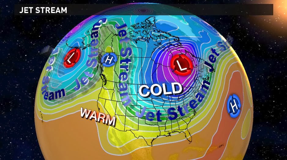
First,
the jet stream in the upper atmosphere is diving far to the south from the
Arctic region. The term polar vortex was
used earlier in January to describe to cold weather seen at that time. Well, it’s baaaaack! This time a piece of the polar vortex is
centered just east of James Bay in Canada.
Cold Arctic air is plunging south to the Gulf coast and covering much of
the Southeast.
 |
| The 500 mb pattern for 00z Tuesday, January 28, 2014. Click on the image for a larger view. Image Credit: WLTX-TV. |
All
of the computer models have been signaling this for the past few days. However, their solutions have differed as to
how and when the precipitation will develop across the Southeast. Some of the models have brought the cold air
in too fast resulting in primarily a snow forecast. Others have slowed the advance of the cold
air which has produced forecasts of freezing rain, sleet, and snow.
One
such model has been the American model (GFS).
The model has been doing a better job of comparing with observations at
the forecast time. This has instilled
more confidence in the eventual outcome.
Therefore,
the scenario for today is similar to the one in the previous post on
Sunday. I expect light rain/freezing
rain to develop sometime mid to late morning.
There could be some sleet mixed in.
The precipitation will be intermittent and light so that travel should
not be impacted through the morning.
Temperatures may be above freezing near daybreak, but will slowly fall
to freezing or below by midday.
Precipitation
will be mixed in the afternoon with a sleet/freezing rain mix for the southern half
of the Midlands to at sleet or sleet/snow mix in the north. This will gradually change to all snow at
some time in the evening. Most of the
precipitation will fall from midday Tuesday to midnight. The heaviest precipitation will be likely in
the evening. This will be when most of
the accumulation occurs. There will be
more ice in the southern Midlands and more snow in the north.
The
scenario calls for two parts to this storm.
First, ice will accumulate. Then
it will gradually change over to snow before ending.
Ice
will begin to build up in the afternoon and peak toward early evening. There will be little ice in the northern
Midlands, but ¼” to ½” of ice is expected for the central Midlands. The greatest ice accumulation will be in the
southern Midlands with closer to ½” of ice.
The
precipitation will change to snow or a snow/sleet mix in the evening and
continue into the early morning hours.
Amounts of 1-2” are expected for the southern Midlands. The central Midlands including Columbia will
see 2-4” of snow. Finally the northern
Midlands will see closer to 4”+ of snow.
Isolated areas might see closer to 5” in the north.
 |
| Ice accumulation from the 18z version of the GFS model. Click on the image for a larger view. Image Credit: WLTX-TV. |
 |
| Snow accumulation from the 18z version of the GFS model. Click on the image for a larger view. Image Credit: WLTX-TV. |
The
forecasts above are closest to my thinking.
These come from the 18z (1 p.m. ET) run of the model. I did see the later version (00z 01/28/14) of
the GFS. There was a little more ice and
a little less snow. The 00z version might
be true, but the 18z version of the model was verifying well.
It
is going to be a #WinterMess. This is
nothing like the snowstorm of 1973 or the ice storm of 2004, but it will create
enough problems. Travel will become
difficult as the snow and ice accumulate.
In addition, the ice accumulation is likely to cause power outages. This is difficult with the cold air that will
settle in for the next few days.
Don’t
dwell on the numbers other than to give an indication to the general snow and
ice amounts. What you see in your area
may not be seen just 20 miles down the road.
There will be many nuances to the winter weather as it unfolds and could
make for an interesting story. It
promises to be an interesting ride. Stay
tuned!
Be
sure to keep up on the latest through the WLTX Facebook page. You can also get timely updates on Twitter by
following me @JimGandyWLTX along with @amyaaronson, @Daniel_Bonds, and
@ChristineWLTX.