Showing posts with label Weather History. Show all posts

Sunday, August 2, 2020

I'm Back

Every year became busier as I progressed through my career. Maybe you noticed the same in your career. Each year I would vow to reduce my workload and enjoy life a little more, but to no avail. Finally it came to the point that I had to prioritize tasks and some had to be dropped. That was the case with my blog.

The blog went on hiatus after my visit to the White House for the release of the 3rd National Climate Assessment. I simply had too many projects to do all of them well. Some of these projects exceeded my wildest expectations and will be the topic of future posts.

Now that I have retired from television I am released from the daily grind of having to make the most accurate forecast. I did not think I would ever tire of this early in my career, but after 44 years it was time to step away.

It has been a little over six years since I last posted on this blog and much has happened in that time. The most time consuming project began in 2013 and it became Gandy’s Garden. At times I combined it with Climate Matters as it was an offshoot from that program. This will be the focus of my next post.

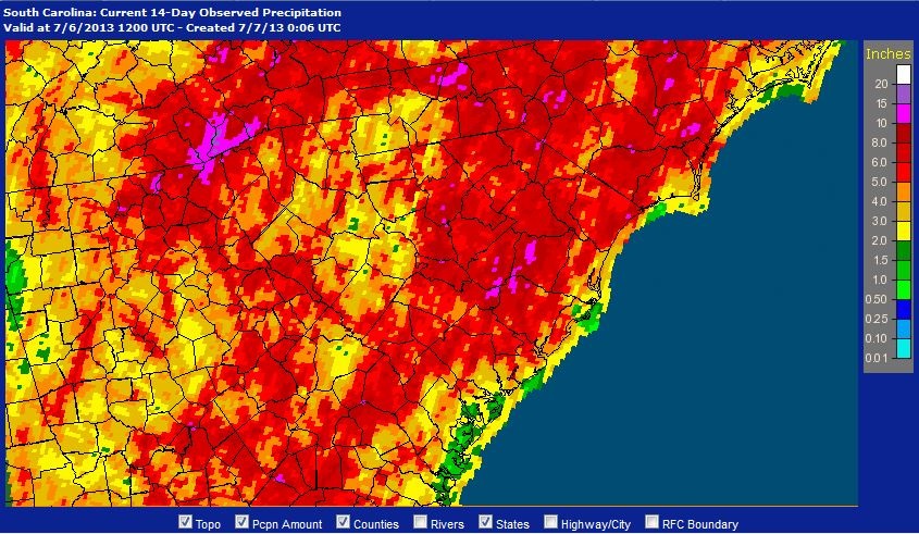
The weather acted up as there were a number of record events like the South Carolina Flood of 2015. The hottest month on record occurred in July, 2016 and in the fall another flood ravaged the eastern part of the state. In 2018 another flood occurred in North Carolina and South Carolina from Hurricane Florence. The town of Nichols, South Carolina was inundated for the second time in two years. There has been much to talk about, but little time to analyze much less talk. Thus, there is plenty of material for the blog over the next few months.

During this time I won awards for specific work and for a lifetime of work. I was awarded an EMMA and an Emmy from the southeast chapter of the National Academy of Television Arts and Sciences in 2016 for the South Carolina Flood of 2015. Later that year I was a Silver Circle awardee for lifelong work as a broadcast meteorologist by the same organization. Upon retiring from broadcasting (not meteorology) I was given a Service Award from the National Weather Service and Special Congressional Recognition from the U.S. House of Representatives (Rep. Joe Wilson). In addition I was given the Key of the City from Columbia (Major Steve Benjamin), and resolutions from Richland County and the SC State Senate.

Receiving a service award from the National Weather Service in Columbia, SC.

Special Recognition from US Representative Joe Wilson.

Receiving the Key to the City from Columbia Mayor Steve Benjamin.

Two rare honors came my way. In 2018 I was elected as a Fellow of the American Meteorological Society. I sometimes have to pinch myself over that one. It was a privilege to be elected in the same year as my friend and colleague Paul Gross.

New Fellows of AMS 2018. President Roger Wakamoto is between me and Paul Gross.

I was given the Order of the Palmetto by South Carolina Governor Henry McMaster for service to South Carolina over the past 34 years upon retirement. This is the highest civilian award given by the state of South Carolina. It means a lot to be recognized by the community in that way.

Receiving the Order of the Palmetto.

It has been humbling to receive so much recognition. Those who know me know that I never expected this. My goal was to do the best job I could for the community by producing the best and most reliable forecast. Our records and those of independent observers rated our forecasts as the best.

Going forward the blog will cover the topics of weather and climate as it has in the past. However, it will sometime delve into topics not directly related to meteorology such as a pandemic. There is so much misinformation on social media that needs to be exposed and corrected. I will try to do that at times with science that is peer-reviewed and not just opinion. My social media presence will continue on Facebook (Jim Gandy WX) and Twitter (@JimGandyWX)

Saturday, February 22, 2014

Remembering #WinterMess 2


Little did we know that the winter storm at the end of January would be the prelude to a bigger storm two weeks later (February 11-13).  A complex storm system came through South Carolina in two waves.  The first occurred on Tuesday with snow over the northern Midlands and rain/sleet elsewhere.  This was followed by the main batch of precipitation on Wednesday ending Thursday morning.

Most of the snow occurred over the northern half of the Midlands.  It was mainly sleet with some snow in Columbia, but the precipitation became more snow farther north.  The northern most counties of the Midlands saw a considerable snowfall.

Total snowfall as of 7 a.m. Thursday, February 13, 2014.  This is based on observations from the National Weather Service Forecast Office in Columbia, SC.  Image Credit: WLTX-TV.

South of Columbia it will a sleet/freezing rain mix.  The farther south you went the more freezing rain occurred.  The southern Midlands saw the greatest accumulation of ice as shown on the map below.

Total ice accumulation as of 7 a.m. Thursday, February 13, 2014.  This is based on observations from the National Weather Service Forecast Office in Columbia, SC.  Image Credit: WLTX-TV.

The Midlands ended up on the dividing line between snow and ice.  The northern half saw a snowstorm while for the southern half saw an ice storm.  Travel became difficult if not impossible through some sections.  The worst of the storm occurred over the southern Midlands with the accumulation of ice.  An estimated 350,000 people lost power at the end of the storm.  Some were without power for over a week.  Schools remained closed for Wednesday through Friday with some of the northern counties closing schools on Tuesday.

Friday, January 31, 2014

A Look Back at the #WinterMess


The snow that everyone graved finally came to the Midlands.  The same storm system that affected Birmingham and Atlanta also affected Columbia, SC.  Rain and sleet began to fall before noon on Tuesday, but it wasn’t enough to measure and didn’t cause any problems.  The lower atmosphere was quite dry so that it would take hours of light precipitation to moisten the atmosphere enough to allow for any significant precipitation.

Finally a band of rain/freezing rain moved across the southern half of the Midlands just before dark.  This was followed by snow in the northern part of the Midlands.  It eventually reached Columbia in the form of freezing rain.  At WLTX we pick up an ice accumulation of 1/10 of an inch before the precipitation changed over to snow.  The southern third of the Midlands saw ice accumulations of a ¼ to ½ inch.

The air was chilled by the rain/sleet/snow mix and temperatures fell below freezing over all of the Midlands shortly after sunset.  The precipitation changed to snow which fell mainly from 7:30 p.m. to about 2 a.m. across the Midlands.  Snow ended from west to east and the amounts didn’t vary a great deal across the Midlands.

A map of the midlands of South Carolina showing total snow depth as of Wednesday morning January 29, 2014.  This is from preliminary data.  Click on the image for a larger view.  Image Credit: NOAA/NWS/CAE.

Amounts were generally 2 to 3 inches across much of the area.  It was a wet snow which made for great snowmen and snowball fights.  Here is a view of the region from the satellite the next day:

Sunday, January 5, 2014

Arctic Cold? I'll take a Double!


The new year is taking up where the old year ended.  The weather pattern discussed in a previous post continues to dominate North America.  Each time the pattern amplifies with a strong ridge-trough-ridge look, cold air invades the U.S.  The pattern relaxes and becomes more zonal causing milder conditions to return.  This is the up and down pattern that has resulted in a roller coaster of temperatures.

This was the 500 mb pattern for North America at 12z December 9, 2013.  Note the ridge-trough-ridge pattern.  Click on the image for a larger view.  Image Credit: WSI.

This was the 500 mb pattern for North America at 00z January 6, 2014 (taken from the ECMWF model 12 hours earlier.  Note the ridge-trough-ridge pattern returns.  Click on the image for a larger view.  Image Credit: WSI.

However, this time there has been a bit of a twist.  A surge of cold, arctic air invaded much of the country at the end of last week.  The temperature in Columbia dropped to 22° F Saturday morning.  The high pressure center moved quickly to the east causing winds to shift bringing clouds back into the area before daybreak.  This locked in the cold air for the weekend and there wasn’t much of a rebound in temperatures.

Saturday, December 21, 2013

Weather's Ups & Downs


It has been like a roller coaster for temperatures since late October beginning with a freeze on the 26th Columbia, SC, when the temperature dropped to 30°F.  This came after an exceptionally warm fall.  Here is a look at the ups and downs since October 26th:

Month
Date
Temp

Oct
26
30°


30
82°

Nov
4
38°


6
77°


9
32°


10
72°


14
23°
New Record Low

18
85°
New Record High; Trace of Snow Evening

19
38°


22
76°


25
22°


26
71°


28
23°

Dec
6
82°
Record High Tied

13
25°


21
81°
New Record High

The forecast for the 22nd of December is for record high temperatures with much colder weather returning for Christmas Day.  Thus the roller coaster will continue for a while.

What is causing this?

Tuesday, October 22, 2013

South Carolina's Wettest Summer


This past summer was cool and wet for Columbia and this was the topic of a previous post.  It turns out that Columbia was not alone.  In fact some areas had much more rain than Columbia.  The mountains of South Carolina saw record rainfall for the summer with an average of over 40 inches.  On August 6th over 5 inches of rain fell in the Upstate resulting in one drowning death in Pickens County.

Summer rainfall averaged for the mountains of South Carolina (division 1) since 1895.  2013 was the wettest on record.  Click on the image for a larger view.  Image Credit: NOAA/NCDC.

The wettest areas were in the Upstate, Pee Dee, north coastal, and central divisions of South Carolina.  These divisions saw record summer rainfall while all other divisions were at least in the top 10 wettest.

A ranking of summer rainfall for South Carolina since 1895.  Click on the image for a larger view.  Image Credit: NOAA/NCDC.

A ranking of summer rainfall for South Carolina since 1895 with other states in the U.S.  Click on the image for a larger view.  Image Credit: NOAA/NCDC.

Monday, October 7, 2013

Karen Fizzles


Karen, the eleventh tropical storm of the season, dissipated along the central Gulf coast Sunday morning.  This was a relief to that area of the country, but was not expected from the forecast three days before.  The Federal Emergency Management Agency (FEMA) had already begun to recall personnel on furlough from the government shutdown.  Keep in mind that meteorologists at the National Weather Service (NWS) and National Hurricane Center (NHC) were already on the job, just not getting paid.

So what happened?

The tropical storm formed Thursday morning north of the Yucatan Peninsula and in my last post you can see what the track models were suggesting.  However, the storm was already being affected by a southwesterly shear aloft and dry air covered much of the western Gulf of Mexico.

The visible satellite picture of Karen for 21z Thursday, October 3. 2013.  The center of circulation is north of the Yucatan Peninsula.  Notice the asymmetry in the storm with all of the thunderstorms east of the center.  Dry air west of the center kept storms to a minimum.  Click on the image for a larger view.  Image Credit: UCAR.

Thursday, September 26, 2013

The Cool, Wet Summer of 2013


This past summer (June 1-August 31) was a great relief from the past three scorching summers.  Remember that the summer of 2010 and 2011 were back to back the warmest summers on record.  Last summer wasn’t quite as hot, but we did see the all-time record high temperature for South Carolina broken when it reached 113 F in Columbia.

It was during this time that much of the region was also battling drought.  There was some rainfall during the normal wet season of summer, but there were few wet months beginning in 2010.  In fact there were only 8 wet months out of 36 ending in 2012.  It looked like it would never change.

However, the weather pattern began to change in February of this year.  Rains began to increase, but it also got colder.  There were shifting patterns throughout the spring, but it too was cool and wet.  Then summer began with a very sluggish pattern that dominated June and July.  It was not as dominate in August, but it was still enough to keep the month on the cool side.

This weather pattern persisted for much of June and July.  Click on image for a larger view.  Image Credit: WLTX-TV.

Thursday, August 8, 2013

A Tale Of Two Halves


This summer has been one of persistence across the U.S. in the general weather pattern.  The West has been too dry and the East too wet.  Severe to exceptional drought covers much of the western half of the country, while flooding and downpours have drenched the Southeast and Mid-Atlantic.  Some areas have seen relief from the devastating drought of last year and it has gotten worse for others.

The U.S. Drought Monitor for August 6, 2013.  This shows the areal extent of drought across the U.S. at this point in time.  Click on the image for a larger view.  Image Credit: NOAA/USDA.

The worst of the drought continues to be in the High Plains, but it is getting worse over much of the Southwest.  This has already led to an above normal wildfire season in the West.

Tuesday, July 23, 2013

From One Extreme To Another


June was a month of extremes across the U.S. Record heat dominated the West, where all time record June temperatures were being set in multiple states. Meanwhile, the same weather pattern that supported the prolonged, intense heat across the West locked in an extremely wet set up across the East. Not only were numerous daily rainfall records set, but both Philadelphia, PA and Macon, GA, ended up with their wettest June ever.

Some of the extreme weather across the U.S. in June 2013.  Click on image for a larger view. Image Credit: Climate Central.

You can also add Augusta, GA, to the wettest June on record.  Bush Field in Augusta received 10.83 inches of rain which was 6.11 inches above normal. An observer near Martinez, northwest of August, received 16.02 inches for June.  This is remarkable since that area of Georgia and South Carolina had been suffering from nearly 3 years of drought until recently.

Sunday, July 7, 2013

From Wet To Steamy


Drought has been the rule since the fall of 2009 in parts of South Carolina.  Only 6 out of the next 36 months saw above normal rainfall in Columbia, South Carolina until 2013.  Then the pattern changed and 2013 has been wetter than normal.  In fact, 4 out of the last 6 months have been above normal and July is likely to add to that total.

The first week of July has been extremely wet. The airport has seen 2.19 inches of rain while the city has received 4.35 inches of rain in just six days.  July is normally the wettest month of the year, but this year has been wetter than normal.  In fact, the last two weeks have been quite wet.

The map below shows the observed rainfall across South Carolina for the past two weeks ending on July 6.  Note that the area east of a line from Lancaster to Columbia to Barnwell has seen the greatest rain with 10 to 15 inches of rain in eastern Orangeburg and southeastern Clarendon counties.  The rain has been less west of the line until you get into the upstate of South Carolina.

The 14-day observed rainfall ending at 8 a.m. July 6, 2013.  Click on image for a larger view.  Image Credit: NOAA/AHPS.

Heavy rainfall has resulted in significant rises in many of the rivers with minor flooding of the Congaree River in the Columbia area.  The Congaree Swamp has seen considerable flooding over the past month closing some of the trails.  This is likely to continue as much of the flood waters from the Upstate have yet to pass through the Midlands.

So, why is this happening?  It turns out that our weather is linked to a pattern which has caused record heat in the Southwest and cooler than normal conditions in the Midwest.

Friday, May 3, 2013

A Dramatic Change This Spring


It is amazing how fast the weather pattern can change.  Temperatures were much below normal at the end of March.  There was a brief warm up at the beginning of April, but a brief cool snap followed.  Finally the cold air retreated leaving much of South Carolina with above normal temperatures.  In a matter of five days high temperatures in Columbia went from 55 degrees F on April 4th to 87 degrees F on April 9th & 10th.

A previous post talked about the delay of spring this year.  High pressure centered near Greenland continued to pump cold Arctic air south into North America.  This was part of the negative phase of the Arctic Oscillation which became extreme in March.  This led to colder temperatures in March than in January.

This image shows the sea level pressure anomaly calculated from NCEP climate reanalysis data from February 25 through March 25, 2013. The area of anomalous high pressure over Greenland illustrates the negative phase of the Arctic Oscillation, by which persistent high pressure blocks Arctic air from moving eastward, causing it to drop down into the middle latitudes and is a contributing factor in keeping temperatures unseasonably cool in Canada and the US.  Click on the image for a larger view.  Image Credit: NOAA.

Friday, April 26, 2013

When Weather Becomes Climate


Note: It has been a busy three weeks which included a week of much needed vacation.  Much has happened in the interim.  I am working on a number of posts which will be rolled out in May.

Meanwhile, many people often confuse weather with climate.  You have heard the refrains like it is so cold, how could the earth be warming?  Or how can we be in a drought when we’re having a flood?  Just when does weather become climate?  Good question!  Meteorologists at the European Space Agency have produced an answer to that question.

The following video is about 12 minutes long, but it is well produced and worth the time to view it.  They have a wealth of information with which to determine climate change and it is interesting comparing weather in the early 1800’s to weather today.  I hope you enjoy this production.

Wednesday, March 20, 2013

Spring 2013: DELAYED


It’s spring!

The vernal equinox on March 20, 2013.  It is that time of year again (it happens twice) when the relative angle of Earth is perpendicular to the Sun, causing equal incoming solar energy to the Northern and Southern hemispheres - as well as equal day and nighttime. At 7:02 ET on March 20, 2013, Earth was at its equinox. At 7:45 ET, the GOES-13 satellite captured this full disk image of Earth.  Click on the image for a larger view.  Image Credit: NOAA.

Both meteorological and astronomical springs have arrived.  The vernal equinox marks the beginning of spring in the Northern Hemisphere.  This is when the vertical rays of the sun are directly over the earth’s equator and crosses the equator on its northward journey.

Funny, it doesn’t feel like spring.  Let me check the forecast:

The 5-day forecast for March 20, 2013 for Columbia, SC.  Image Credit: WLTX-TV.

Remember those groundhog forecasts from six weeks ago.  A couple of them got it right, but most got is wrong.  Not only did spring not come early, it does not appear to be in sight.

Monday, March 4, 2013

Southeast Drought Improves


What a difference a month can make.  The drought situation was becoming serious at the end of January as I wrote here.  Yet, February saw an abundance of rainfall creating a substantial surplus for the month.

Monthly rainfall for February in Columbia, SC.  Image Credit: WLTX-TV.

Monthly observed rainfall for February, 2013, covering South Carolina as well as parts of Georgia and North Carolina.  Click on the image for a larger view.  Image Credit: NOAA/AHPS.

In South Carolina the heaviest rainfall occurred over the southern half of the state.  Some parts of the low country saw over ten inches of rain for the month.  The least rainfall occurred over the north central section where rainfall was in the three to four inch range.  However, this area saw more rain in January so that the two-month total is substantial.

A series of storm systems moved through the Southeast pumping moisture from the Gulf of Mexico northward.  The heaviest rainfall occurred across southern Alabama, southern Georgia, and parts of northern Florida.  The drought was center in central Georgia which had experienced extreme to exceptional drought conditions for over a year and a half.

Monday, February 11, 2013

Remembering The 1973 Snowstorm In South Carolina


February 9-10, 2013 marked the 40th anniversary of the greatest snowstorm to hit South Carolina in modern times.  Snow in the South is rare enough, but this set many records across the states of Georgia and South Carolina.  Here are some of the notable snowfalls from the storm:

                        Rimini, SC                              24 inches
   Macon, GA                            19 inches
                        Branchville, SC                      19 inches
                        Lake City, SC                         17.5 inches
                        Blackville, SC                         17 inches
                        Columbia, SC                         16 inches
                        Aiken, SC                               15 inches
                        Summerville, SC                    15 inches
                        Springfield, SC                       15 inches
                        Kingstree, SC                         13 inches
                        Camden                                 12 inches

These are just a few of the totals from this remarkable storm.  Generally the snowfall was between 10 to 20 inches over much of central Georgia and central and southern South Carolina.  Winds will strong enough to produce drifts to 5 feet in Sumter and Clarendon counties.

Many refer to this storm as a blizzard and to many in the South it seemed like one.  However, I could not find evidence that it met the criteria for one.  No doubt it was a significant snowstorm which would rival storms much farther north.

Timing is everything for snowstorms in the Deep South.  Typically when it gets cold enough to produce snow the air is too dry.  The right mix of cold air, moisture, and intensifying storm are rare.  Thus, forecasting such storms is quite challenging.

The challenge was much greater back in 1973.  Knowledge about the dynamics of such storms and the modern technology to forecast them was not as advanced as today.  Geostationary satellites were not in standard use or available to local forecasters.   It would not be until the 1980s that much of the dynamics would be known and satellites would be commonplace for forecasters.  The forecast of the New England blizzard this past weekend, days ahead, would have been impossible back then.

Wednesday, February 6, 2013

The Southeast Drought Continues


Droughts can be insidious.  Just when you think they’re gone, they’re back.  Actually it never went away in the Southeast, it just moved around.  The center of the drought began in northeast Florida in 2011 and moved to southern Georgia a year later.  Now the center of the drought is central Georgia and it is beginning to expand thanks to a dry January.


The Drought Monitor for the end of January 2011-13.  Click on the image for a larger view.  Image Credit: USDA.

The current drought began in the Southeast with the end of El Nino in 2010.  That was followed by two years of La Nina which brought drier than normal conditions particularly in the winter and spring.  The worst of the drought has been centered in central Georgia where extreme to exceptional drought conditions have persisted for two years.

However, drought conditions for southeast Georgia and northeast Florida actually disappeared this past summer thanks to two tropical weather systems (Beryl & Debby) which inundated the region with rain in late May and June.  Drought is creeping back into those areas.

Monday, February 4, 2013

Groundhog Predictions


This past Saturday (February 2) was Groundhog Day, a day of anticipation by many tired of winter.  Each year people wait to see what the groundhog has to say about the coming spring.  The most famous groundhog is Punxsutawney Phil in Pennsylvania and has the longest running record.  Predictions from 1888 to 1900 were intermittent and became regular after that time.

Punxsutawney Phil comes out of his hole each Groundhog Day, like clockwork, to tell us if we can expect an early spring or another six weeks of winter. If Phil sees his shadow, he’ll go back underground to wait out the next chilly month and half. If there’s no shadow, Phil — and the rest of us — know that spring is right around the corner.

Average temperature for Columbia, SC, from February 2 - March 16.  Image Credit: Climate Central.

The six-week period that starts on February 2nd has been getting gradually warmer in Columbia since 1887. The warming hasn’t been uniform: you can see from the graph above that some years are cooler than average and some are warmer, but the overall trend is slowly upward. This is consistent with the rising global temperatures that climatologists have predicted with increasing certainty for decades.